Google Map’s Street View now does more than direct you around places or show terrible images of your house on web. Yes, it has turned an adventurous explorer which showed you parts of the world you always wished to see, taking you to the Grand Canyon or burrow in the beauty of the Amazon Rainforest. What More, you could even traverse inside offices, or check out the fishes and shoals underwater. Now, the ‘adventurous’ quotient has just gone up, with the Maps now scaling the great heights of mountains like Mt. Everest, Mt. Kilimanjaro, Mt. Elbrus and many more.
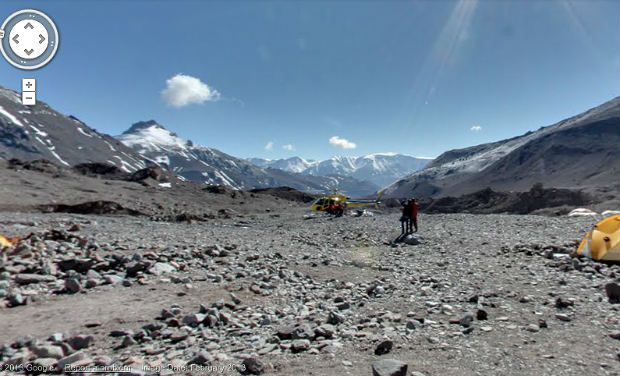
While the Grand Canyon views were developed by Google’s new Trekker backpack camera, the mountain views have been shot using a tripod and a digi-cam equipped with a fisheye lens.
You can check out the full collection of photos shot from the summits and some surrounding landscapes here, and you may even read about the team of Everest trip on the Google Maps blog. You won’t get the same thrill of scaling these summits yourself, but at least you avert a frostbite.

Google Map’s Street View now does more than direct you around places or show terrible images of your house on web. Yes, it has turned an adventurous explorer which showed you parts of the world you always wished to see, taking you to the Grand Canyon or burrow in the beauty of the Amazon Rainforest. What More, you could even traverse inside offices, or check out the fishes and shoals underwater. Now, the ‘adventurous’ quotient has just gone up, with the Maps now scaling the great heights of mountains like Mt. Everest, Mt. Kilimanjaro, Mt. Elbrus and many more.
While the Grand Canyon views were developed by Google’s new Trekker backpack camera, the mountain views have been shot using a tripod and a digi-cam equipped with a fisheye lens.
You can check out the full collection of photos shot from the summits and some surrounding landscapes here, and you may even read about the team of Everest trip on the Google Maps blog. You won’t get the same thrill of scaling these summits yourself, but at least you avert a frostbite.